Offering many of the Byway’s most spectacular attributes, tour the Nisqually area, explore Mt. Rainier National Park and discover the Big Bottom Valley. Drive amongst old-growth forests, walk through meadows of wildflowers and witness the area’s animal inhabitants. Tour friendly mountain communities and discover the interesting area history. A wonderful opportunity to get to know the west end of the White Pass Scenic Byway.
Road Trip Itinerary
Length: 115 miles
Driving Time: 3 hours (allow extra time for stops)
Open Season: The route is usually snow-free by the end of May and remains open through October. The road closes between Paradise and Ohanapecosh Visitor Center each year due to winter snowfall from November to May.

Driving Directions: From the intersection of US Highway 12 and State Route (SR) 7 in Morton, travel north on SR 7 for 16.8 miles to SR 706. Turn right on SR 706 and travel 52.1 miles to SR 123. Turn right on SR 123 and travel 5.5 miles to US Highway 12. Turn right on US Highway 12 and travel 40.7 miles back to Morton and the intersection of US Highway 12 and SR 7.

Start: This journey begins in the mountain community of Morton located on US Highway 12. Morton offers lodging and dining options, as well as support services including a hospital and two full service grocery stores.
Stop 1: Loggers’ Memorial – Stop at Morton’s Loggers’ Memorial, recognizing loggers who gave their life working in the forest industry. Morton is a proud logging community with a long history of forestry. At one time, over 100 mills were located in the area.
Stop 2: Morton Depot – Recently relocated and restored, see Morton’s historic train depot. Currently it is being developed into a visitor center and museum as well as a hub for revitalized excursion train service. This historic 1910 building is architecturally distinguished and anchors the community’s revitalized downtown.
Stop 3: Mineral Lake – Traveling north on SR 7, a stop at Mineral Lake is a must. With majestic Mt. Rainier as its backdrop, 277-acre Mineral Lake offers rest, relaxation, and world-class trout fishing. People flock from all over the northwest to sink their line in these fish-filled waters. Others prefer swimming, boating and taking in the unbeatable Mt. Rainier views. A public boat launch allows boaters and anglers to enjoy a day on the water.
Stop 4: Historic Mineral Lake Lodge – Listed on the National Register of Historic Places, visit Historic Mineral Lake Lodge. This grand three story log structure was built in 1906 to resemble the rugged elegance of a German wilderness hunting lodge. Today it is privately owned and serves as a lovely bed and breakfast establishment. From the veranda witness magnificent views of Mt. Rainier and the Nisqually River Valley. Inside, view numerous antiques, old photographs and articles reflecting the history of the area.
Stop 5: Post Office – Just a short distance from the lodge, on the right side of the road, see the nation’s smallest post office. This eight feet square structure was built in 1898. A wooden plaque describes its place in Mineral’s history.
Stop 6: Elbe Evangelical Lutheran Church – Since 1906, the Elbe Evangelical Lutheran Church has watched over the mountain community of Elbe. Built by German immigrants, this tiny, charming church is listed on the National Register of Historic Places and still contains many of its original items including its 4-foot iron cross on top of the 46-foot bell tower-steeple housing its original bell as well as the original alter, and one pew.
Stop 7: Ashford Visitor Center and Base Camp – Located in the Summit Haus along SR 706, just outside Mt. Rainier National Park, stop by the Ashford Visitor Center offering a wide selection of brochures and area information. Discover the wide variety of recreational opportunities and services offered in this southwest corner of Mt. Rainier National Park.
Stop 8: Nisqually Entrance – Standing at the Nisqually Entrance to Mt. Rainier National Park notice the wooden entrance arch built in 1922 and reconstructed in 1973. Just inside this entrance see the oldest building in the park, a cabin built in 1908 that was occupied by a park ranger. This district is listed on the National Registry of Historic Places. It is the only entrance to the park opened year-round. You are now inside the park – drive slowly and enjoy winding through the impressive old-growth forests.
Stop 9: West Side Road – At 0.9 miles inside the park, the West Side Road turns left and can be driven to where the road is gated at 3.3 miles. The road is closed at this point because of hazardous outburst floods and mudflows. Hikers often walk or bicycle the road from the closure to trailheads for several hikes including Tahoma Creek, Klapatche Park and Gobblers Knob. During the winter months this area is a popular destination for winter recreation.
Stop 10: Kautz Creek – The Nisqually-Paradise Road continues to the Kautz Creek Bridge at 3.3 miles. This is the site of a massive mudflow which occurred in 1947. The original road through this area now lies 20 feet below the surface. A parking lot will allow you to get out and take a look around. Take a short walk along a fully accessible boardwalk leading to an overlook of the 1947 debris flow and a splendid view of the mountain. Notice the young forest that has undergone a complete succession of re-growth within the past fifty years. A popular trailhead for the Kautz Creek Trail leading to Indian Henry’s Hunting Ground departs from this point. It is also a link to the world-renown 93-mile Wonderland Trail.
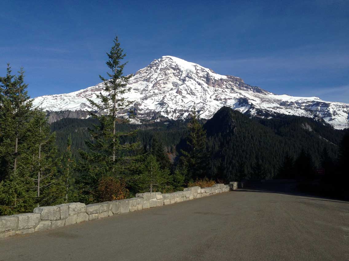
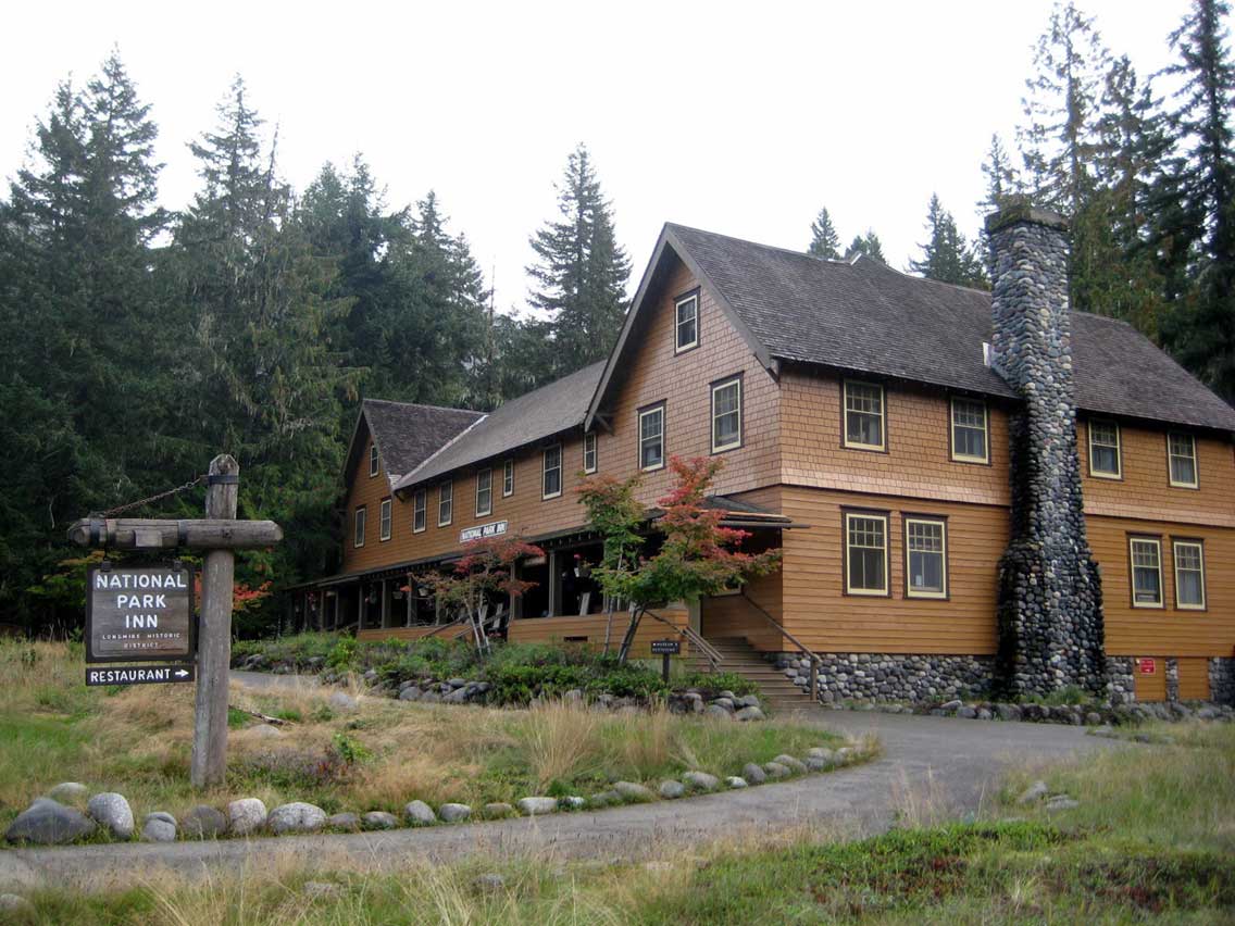
Stop 11: Longmire – Open daily, year-round; be sure to stop in at Longmire. This is your first grand view of the mountain. Visit Longmire Museum, one of the oldest museums in the National Park System with several exhibits on the cultural and natural history of the park. Stop in and take a look around the beautiful and rustic National Park Inn. Offering a full-service restaurant and gift shop, as well as a cozy lounge and oversized stone fireplace, it is the perfect place for relaxation on the mountain. See the historic 1911 log cabin adjacent to the inn, housing a general store. Also located here is the Longmire Wilderness Information Center with information on hiking and climbing in the area. From Longmire, stretch your legs with a walk along the Trail of the Shadows. This loop trail explores a mineral hot springs discovered in 1883 by James Longmire, an early settler in the region. The short nature trail displays an early original homestead cabin and a variety of plants and animals. In the winter this pathway is a popular snowshoe trek. Another nice afternoon stroll is to walk through the operations and residential area and cross the wooden suspension bridge over the Nisqually River to a magnificent view of the mountain. It is also a starting point for hikers of the Wonderland Trail.
Stop 12: Christine Falls – Just up ahead, the road passes very pretty Christine Falls. There is a turnout on the right to get out and have a better look. This waterfall can be viewed without having to lace up your hiking boots. Notice the 1928 stone masonry highway bridge forming a picturesque frame over the lovely 40 foot falls as it splashes down the lower reaches of Van Trump Creek. A small flight of stairs leads to another beautiful lookout of the falls.
Stop 13: Ricksecker Point Loop Drive – Six miles down the road, the one-way Ricksecker Point Road (signed as “Viewpoint”), offers fantastic views of the area’s beauty. See it all — views of Mount Rainier, Nisqually Glacier, Eagle Peak, Rampart Ridge and several of the mountain’s 25 glaciers including Pyramid, Success, Kautz and the Wilson Glacier. You can also see Point Success – the false summit of Mt. Rainier, Gibraltar Rock and Cowlitz Cleaver. The cone-shaped peak down the valley is Tumtum Peak. The Ricksecker Point Road is open in the summer only.
Stop 14: Narada Falls – Don’t miss Narada Falls at 15.5 miles; there is plenty of parking. Walk the short trail to a view of the falls at 0.2 miles. If you time it right you may catch rainbows dancing in the mist of the falls. This massive 168-foot waterfall is truly breathtaking, as the waters fan a thick mist out over this popular viewpoint.
Stop 15: Glacier Vista Viewpoint & Exhibit – Be sure to stop at the pullout on your left to take a look at the Glacier Vista Exhibit. Learn about the fascinating glaciers of the mountain. Look up to the summit and see Nisqually glacier and its origin on the permanent Nisqually snowfield. Beginning at 14,000 feet, this is the fastest moving glacier on the mountain, moving at over one foot a day.
Stop 16: Paradise – Discover Paradise. At 5,400 feet, this area with its glorious views of Mount Rainier is the primary destination for many visitors to the park. Tourists are drawn to the area year-round. In the summer months, alpine meadows are ablaze with the color of the wildflowers and during winter, its deep snow is ideal for cross-country skiing and snowshoeing. The Henry M. Jackson Memorial Visitor Center offers interpretive displays about the geology, flora, fauna and mountain climbing in the area. The Jackson Grill, a book store, gift shop and information on climbing Mt. Rainier are also located here.
It’s just a short walk to the historic Paradise Inn with rustic rooms, the Paradise Inn Dining Room, Glacier Lounge, and a gift shop. Built in 1917, this beautiful inn displays hand-crafted furniture, a magnificent 14 foot grandfather clock and a rustic piano built by a German carpenter. Leaving from both the inn and visitor center is one of the most popular activities at Paradise — the short, family-friendly, paved nature trails. Suitable for just about everyone, these pathways lead through colorful meadows and offer spectacular mountain vistas. On the Nisqually Vista Trail, walk where the clouds go and see how weather shapes the landscape, plants and animals of these high-country meadows. See splendid fields of wildflowers while taking in the stunning views of Mount Rainier and Nisqually Glacier. And keep your eyes peeled for area residents — the amusing whistling marmots sunning themselves on the rock outcroppings. During the winter season, the road is not plowed beyond this point.
Stop 17: Reflection Lakes – Now descending down the mountain, stop and see Mt. Rainier’s stunning reflection in the crystal waters of Reflection Lake. Its picture-perfect beauty makes it one of the most photographed areas of the park — and you can get there by car. On a peaceful day, the reflection is almost too grand! For the best view, walk to the end of the turnout. A short trail leads to the lake shore, but sorry anglers, no fishing is allowed. In spring and summer, enjoy the beautiful wildflowers that line its shores. In autumn see the huckleberries that have turned brilliant shades of red and orange. Just across the road is the trailhead for the popular but steep trek to Pinnacle Peak.
Stop 18: Martha Falls Viewpoint – The road switchbacks into Stevens Canyon where there is roadside parking for a view across the canyon of Martha Falls below Unicorn Peak. Water spills 150 feet in a dramatic display along Unicorn Creek. Watch the water plunge into the glacial valley, once occupied by Stevens Glacier.
Stop 19: Box Canyon – A fascinating feature of Mt. Rainier National Park is intriguing Box Canyon. The Muddy Fork of the Cowlitz River at only a few feet wide has over time cut a channel into the mossy rock, a canyon 100 feet deep but only 15 to 30 feet across. Walk a bridge across the canyon for a dizzying view of this deep forest canyon. A nice picnic area is also located here.
Stop 20: Backbone Ridge – In a little over four miles, pull off to the right into a parking area for one more look at splendid Mt. Rainier. Looking up the valley, see the mountain and its summit. For those with a sharp eye, look to see a portion of Margaret Falls. Cascading over 1,100 feet, this is the park’s tallest waterfall.
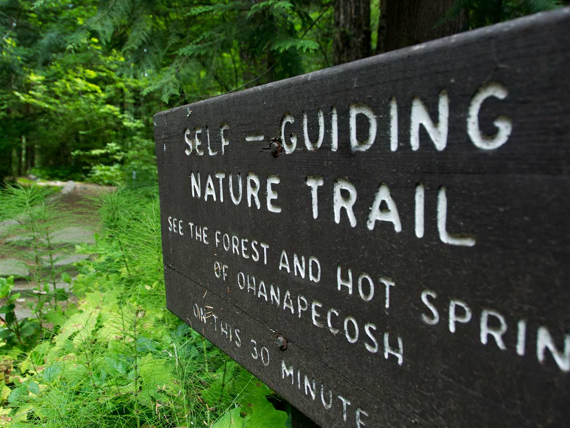
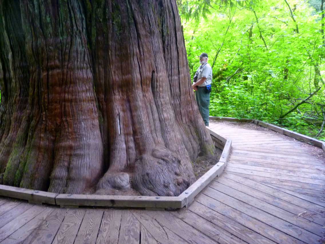
Stop 21: Grove of the Patriarchs – Everyone in the family will enjoy an easy 1.5 mile loop through Grove of the Patriarchs, an excellent example of old-growth forest. Witness ancient stands of gigantic Douglas-firs, western hemlock and western red cedar, some estimated to be over 1,000 years old. People come from all over the world to experience walking through ancient forests of trees with 30-foot circumferences. To reach the trailhead, turn into a parking area (left) just before a bridge over the Ohanapecosh River.
Stop 22: Ohanapecosh Visitor Center – Back down to an elevation of 1,914 feet, make a stop at Ohanapecosh. Situated among Douglas firs, western red cedars, and western hemlocks, visitors can experience the beauty and complexity of an old-growth forest. This lush area offers a visitor center featuring exhibits about local history, wildlife and the old-growth forests found in this southeast corner of the park. Speak with a park ranger and learn more about the fascinating geology of the area. See the remains of the historic hot springs in the boggy area near the visitor center. Guided interpretive programs, maps, restrooms and book sales are available. Also find the very popular Ohanapecosh Campground. A well designed camping area; sites are sorted into smaller loops to keep visitors from feeling overcrowded. The Ohanapecosh River roars through the campground, separating the two major camping areas.
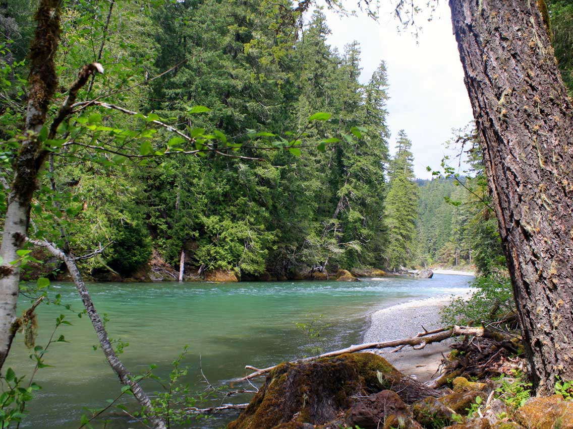
Stop 23: La Wis Wis Campground – Back on the White Pass Byway, stop at La Wis Wis Campground and stand among the giants — giant trees that is. This nicely forested campground is situated at the convergence of three rivers. Many trails lead to the water’s edge. Take a short walk along one of these trails and enjoy a bite to eat at the day use picnic area.
Stop 24: Visit Packwood – For more area information, stop at Packwood Visitor Center. Find brochures, maps and fliers detailing local and regional recreational activities and events. Find information about the neighboring Gifford Pinchot National Forest provided by the local Cowlitz Valley Ranger Station.
Stop 25: Hotel Packwood – Making your way through the heart of downtown Packwood, stop in for a look at Hotel Packwood. Maintaining its historic, old-time charm, this 1912 establishment is furnished with antiques and offers a look at life in the early 1900’s. Sit and relax in the cozy lobby featuring a brick fireplace and historic piano.
Stop 26: White Pass Country Historical Museum – Discover the fascinating area history of the Upper Cowlitz Valley from Kosmos to White Pass, at the White Pass Country Historical Museum. It offers educational programs and interpretive discussions as well as exhibits and displays. Find the museum in the former Packwood Elementary School. Summer Hours: Saturdays Noon – 5 p.m.; Sundays 1-3 p.m.
Notice: Goat Rocks Wilderness – Along the way, notice the rocky terrain of the Goat Rocks Wilderness. Named after the goats inhabiting the area, it is actually part of an ancient volcano, eroded over time. Today this scenic area offers hiking, wildlife watching, camping, and rock climbing for the outdoor enthusiast.
Notice: Cowlitz Valley Elk Habitat – Venturing further yet, find yourself in the “Big Bottom Valley”. It is at its best here — a wide river plain with the Cowlitz River winding through rich farmland and riparian areas. Keep your eyes peeled. Fields in this area are often filled with elk, quietly grazing in the bottomland areas.
Stop 27: Cowlitz Valley Ranger Station – To learn more about the Gifford Pinchot National Forest, stop in at the ranger station and chat with a local forest ranger about the area. Also available are book sales, a gift shop, forest permits, updates on road and trail conditions, as well as campground information.
Stop 28: Woods Creek Watchable Wildlife Area & Access to Mt. St. Helens National Volcanic Monument – A short distance down Forest Road 25, find a great opportunity to learn about the area’s wildlife and their habitats, on the 1.5 mile Woods Creek Trail. Meandering through five different habitats, it’s an excellent hike for children, and presents many opportunities for bird watching and plant identification. Bring along a plant identification book and study all the different varieties of vegetation along the path.
To visit Mt. St. Helens National Volcanic Monument and Windy Ridge, continue on FS 25.
Stop 20: Lake Scanewa and Cowlitz Falls Dam – A few miles off the byway, drive to Lake Scanewa and view Cowlitz Falls Dam. A favorite location for anglers and families, the lake is well stocked with rainbow trout and offers a family-friendly area to picnic and play at Bud Allen Park.
Stop 30: Taidnapam Park – Located in a beautiful natural setting, relax for a bit and bask in the beauty of the great outdoors at Taidnapam Park. Watch the bald eagles and osprey soar through the skies. Be on the lookout for native plants such as Oregon grape, salal, red flowering current and sword fern. The wheelchair-accessible fishing bridge is a unique location for youngsters to catch their first fish.
End: The route comes to an end as it returns to Morton.
Roads in this itinerary can be windy and many have steep drop offs on the either side. Always drive with caution and expect wildlife. Please check local ranger stations for winter road closures.
![]()
Download the West Side Loop Road Trip Itinerary