Explore the Byway: Windy Ridge and Mount St. Helens National Volcanic Monument
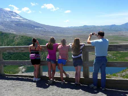
Enjoying the view at Windy Ridge
There are three sides of Mount St. Helens that are accessible to the public; on this outing we visited the northeast side of the volcano, often referred to as the Windy Ridge side. We set the odometer at zero in Randle after turning off of US Highway 12 onto SR 131 (it is also Forest Service Road Rd No.25).
At 5.8 miles from Randle we passed the Woods Creek Watchable Wildlife area and the Iron Creek campground at 9.7 miles. The roads at lower elevations are lined with foxgloves, ferns and goatsbeard now, during the summer. This is also logging country where trucks hurtle along through dappled light on forest service roads, coming and going to jettison or pick up a load of timber.
A slide area is passed at about 14.5 miles where a stream is crossed on a bridge. At 20 miles from Randle we turned right onto Forest Service Road No. 99 (Windy Point is 36 miles from Randle). We next stopped at the Bear Meadow Interpretive Site (left) with views of Mount St. Helens (24.7 miles). Views grow even more expansive the further you drive; at 26.7 miles there are views of Mount Adams, Mount St. Helens and the Clearwater valley. We also passed Forest Service Road No. 26 that leads to the popular trek to Norway Pass.
Our next stop was the Miners Car Viewpoint and a short path to Meta Lake (29 miles from Randle). At the Miners Car Viewpoint the twisted, burnt-out Pontiac tells a silent and horrific tale about the family that hiked to a miner’s cabin when the mountain erupted in 1980. They tried to escape but did not survive.
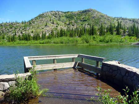
Blue waters at Meta Lake
Though the crumpled, burned metal of the car is sobering, take heart in seeing how the region is returning to life. Fireweed has poked its way through the rusted roof of the car and the tall evergreens you see lining the path to Meta Lake were mere seedlings during the eruption; already they have formed a cool, sheltering forest along the trail. Fireweed, mountain ash, Indian paintbrush, penstemon, yellow composites, lupine, valerian and alders are also thriving along the trail to the lake. From Meta Lake you’ll view an area once described as Hell where today the hills that were denuded by the blast are dotted by evergreens.
Before the eruption on May 18, 1980 Meta Lake was covered with snow and ice; this enabled some of the fish to survive the blast. The melting ice from the blast formed a protective layer that helped protect the fish. The trees near the lake are firs that were small enough to be covered by the snow pack; taller trees were killed (plants and animals that survive and/or return are called colonizers).
We also stopped at the Cascade View viewpoint (30 miles) with views of Mount Adams. At 32.2 miles from Randle we passed the trailhead to Independence Pass (a trail connection to Norway Pass).
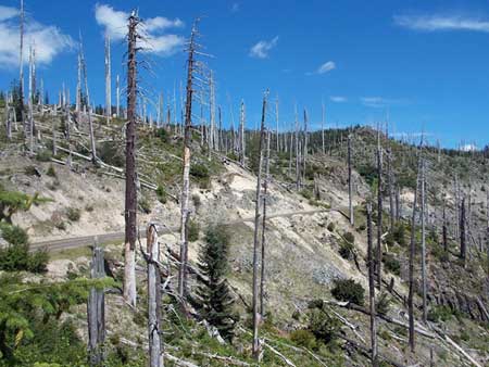
Forest Road 99 through the Blast Zone
At 33.5 miles we stopped at the Harmony Viewpoint where the 1-mile long Spirit Lake trail descends 700 feet to the lake, the only legal access to Spirit Lake. The peace and quiet of the Harmony Falls Resort was lost during the recent eruption. Gone were the days when families stayed at the resort on tranquil Spirit Lake to escape the angst and the hustle-bustle of the 20th century. Regrettably we’d never been there and will never experience the story-book tranquility of the resort. During the 1980 eruption the lodge was destroyed in seconds as a giant avalanche swept down the mountain and slammed into the lake; the waves were reported to be up to 850 feet high. Trees were snapped like pick-up-sticks and tossed mindlessly into the lake creating a layer of logs. The eruption was to powerful it enlarged the lake making it a mile longer and a couple hundred feet higher than it was before. If you hike the trail to Spirit Lake be sure to stay on the trail as the surrounding area remains closed for research.
Our next stop was Cedar Viewpoint (33.9 miles) and just beyond, the Donnybrook Viewpoint with views of Mount St. Helens and Spirit Lake. Here you will see logs from the eruption still floating on the surface of the lake. At 34.9 miles is the Smith Creek Trailhead and at 35.4 miles the Smith Creek Viewpoint.
We topped out at Windy Ridge (36.5 miles from Randle), having made several “unofficial” stops for views where pull-outs allowed us to do so safely. At Windy Ridge there’s plenty of room to park, a restroom and the amazing Windy Ridge Sand Ladder that leads to a higher, designated viewpoint and interpretive signs.
Ascending the stairs at Windy Ridge
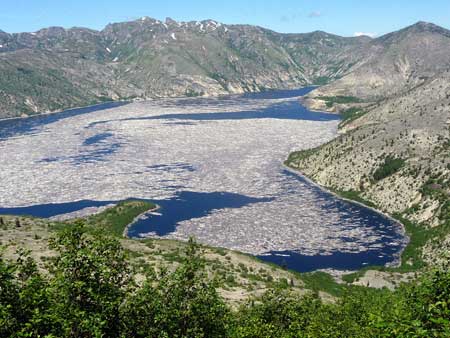
The Windy Ridge viewpoint must be seen to be believed with its 360-degree views of Mount St. Helens, Mount Adams, Mount Rainier, Mount Margaret and startling views of Spirit Lake with its islands of floating trees blasted from the earth, driven with fierce velocity into the lake, the trees on the adjacent hillsides flattened as if by a giant’s angry breath. You can also see the Pumice Plain, Spud Mountain, Elk Rock, Johnston Ridge, and Harry’s Ridge.
Windy Ridge is at 4,000 feet and is about as close as you’ll get to Mount St. Helens unless you make a reservation to climb the volcano (reservations are booked months ahead). From there take in views of other peaks including Mount Margaret (far right). The logs you see floating on Spirit Lake today once covered the entire surface of the lake (they are slow to sink and can float many years).
On the way back from Windy Ridge we stopped at the Smith Creek Viewpoint to view the headwaters of Smith Creek. During the eruption a mudflow poured down the creek. When you look at Mount Adams from there imagine how the climbers on Mount Adams that day must have felt on that fateful day in 1980 when the mountain erupted. As ash began to fall the climbers vacated the peak as fast as they could. That ash was carried all the way to Yakima and Ritzville!
Spirit Lake from the Truman Trail
No matter where you stop you cannot help but get a chill up and down your spine when you imagine David Johnston, the geologist, who didn’t stop shooting photographs of the erupting volcano until he was overtaken by the blast, not to mention the losses of families who lost kin during the eruption and its horrifying after-effects.
Before you return to civilization take time to walk down to Iron Creek Falls (you’ll find the parking area on your right along the forested road near the Iron Creek Campground). Here, a short path drops to the base of the falls. The route to the base of the waterfall is a little challenging to get to as logs and root-balls have blocked easy access but the view is still stunning. Go left to see a pretty pool formed by the waterfall; it is much easier to get to.
Additional Information
- Maps: Green Trails No. 332 Spirit Lake
- For more information on Mount St. Helens National Monument see www.fs.usda.gov/giffordpinchot or call 360-449-7800.
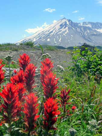
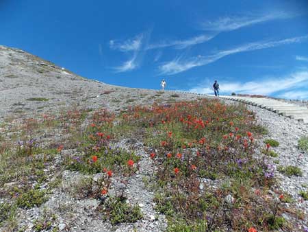
Mount St. Helens and Indian Paintbrush
Hiking Trails
Norway Pass is accessed by Forest Service Road No. 26 and via the Independence Pass trailhead on Forest Service Road No. 99. The trail can be hiked in either direction and will appear on this site in the near future. The trail is six miles one-way starting from the Norway Pass trailhead on Forest Road No. 26. The best views purportedly begin in about two miles with views of Spirit Lake (with two cars you can arrange a six-mile one-way hike via Independence Pass).
The Truman Trail (from Windy Ridge via the sand-ladder): It is 1.4 miles to Forest Service Road 99 which is where it connects to Trail 225 (the Smith Creek Trail). Follow the Truman trail along Windy Ridge as far as your hiking experience and comfort zone allow (the Truman trail essentially continues from the designated viewpoint on Windy Ridge).
Note: Confusion is possible because of the discrepancy of the trail numbers on the Green Trail map which shows Trail No. 227 where the sign at the top of the sand-ladder shows Trail No. 207.
Download this itinerary route.
By Karen Sykes for the White Pass Scenic Byway