Immerse yourself in the heart of the Mt. St. Helens Blast Zone and experience the stark contrast between the lush old-growth forest and the blown-down forest. To experience the many beautiful and fascinating hikes in the area, a Recreation Pass may be required for parking.
Road Trip Itinerary
Length: 74 miles
Time to Allow: 4- Hours
Open Season: The route is usually snow-free by the end of May and remains open through October. The road closes each year due to winter snowfall from November to May.

Driving Directions: From Randle travel south on State Route (SR) 131 until the road forks (1 mile). Stay to the right, traveling on SR 131 which becomes Forest Road (FR) 25 (1 mile). Travel south on FR 25 to FR 99 (19 miles). Turn right on FR 99 and drive until it terminates at Windy Ridge (16 miles). Return to Randle via the same route.
Get the Scoop: Journey the Road to Windy Ridge with Hiking Expert Karen Sykes. Read the story.

Start: This journey begins in the small mountain community of Randle located on Highway 12. Restaurants, vehicle and RV services, and campgrounds are available.
Stop 1: Woods Creek Watchable Wildlife Trail – One of many short and family friendly hikes along this route is the Woods Creek Trail #247. This scenic and serene 1.5 mile loop travels through five habitat areas, offering hikers an opportunity to learn about the wildlife and their habitats. This path passes through a mixed hardwood conifer forest, winds along the edges of a meadow, follows a beaver pond and enters a hardwood forest that offers a burst of color in the fall. A favorite area for bird watching, bring a guidebook along and name the many feathered friends that call this area home. For a longer walk, continue on Trail 247A, the Old-Growth Loop, taking you through an old-growth Douglas-fir stand. The area also offers a day-use picnic area and restrooms.
Stop 2: Iron Creek Campground & Picnic Area – Located along Iron Creek and the Cispus River, stop a moment to soak in the surrounding beauty at popular Iron Creek Campground and day-use area. From the picnic area, enjoy a walk along the 0.3 mile signed Iron Creek Old-Growth Trail. Weave through old-growth forests of fir, cedar and hemlock while following the scenic Cispus River. For a longer hike, continue for 1.5 miles on the Iron Creek Campground Trail. This trail is a barrier-free trail designed for everyone, including people with disabilities, families and anyone else looking for a wide, level trail. The first half of this trail continues to follow the stunning Cispus River. There are occasional benches and turnouts so stop a moment and listen to the sounds of the forest and river. See the remains of an old railroad trestle over the riverbed. The trail leaves the river on the northwest corner of the loop through magnificent stands of Douglas-fir and Western red cedar. Just a few miles further on FR 25, stop for a short nature walk to view Iron Creek Falls. One of the prettiest waterfalls in the area, it pours powerfully off a cliff and into a large clear pool. Downstream from the falls is a great place to let the kids splash around and play in the creek at low water levels.
Stop 3: Wakepish – Following the twists and turns of this scenic route, the next stop is Wakepish Picnic Area and SnoPark. A sno-park in the winter, this area offers parking, a picnic area and restrooms. The perfect place to drop off a trailer or RV before heading up to Windy Ridge.
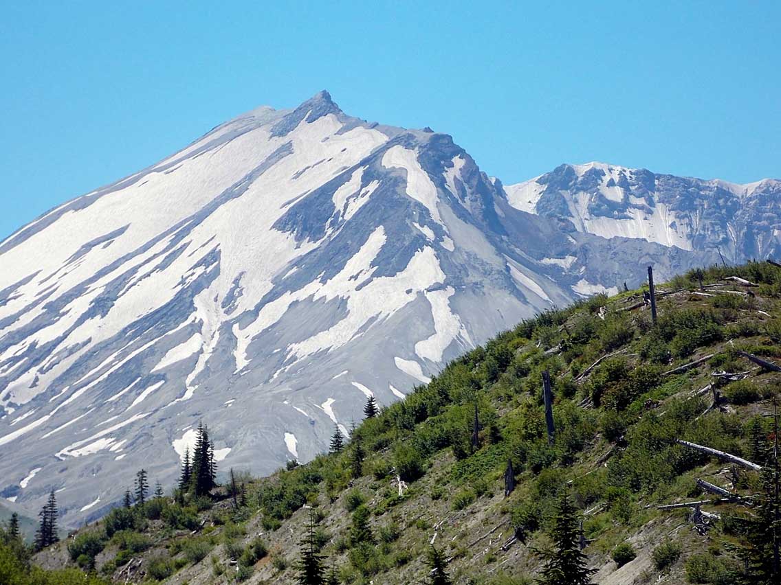
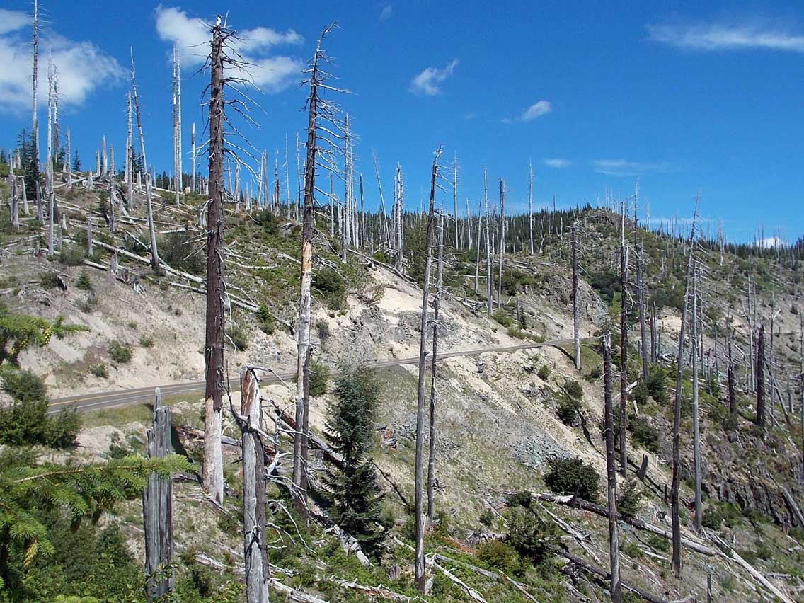
Stop 4: Bear Meadow – Making your way toward the volcano, stop at Bear Meadow. The vistas are both dramatic and thought-provoking. See grand views of Mount St. Helens and ponder the vast transformations in this area. It was at this location the morning of May 18th, 1980 that photographer Gary Rosenquist took the famous, four quick-succession photos of the mountain’s explosive eruption. After shooting the pictures, he and his friends made a harrowing drive to escape. These four pictures are now reproduced on the interpretive sign at the viewpoint. This stop also offers access to the 32 mile Boundary Trail/Truman #207. Climb gently through old-growth forest, along babbling streams, eventually entering the blast zone. Notice the surreal landscape of gray, the decapitated trees and the carpet of pumice beneath you. Restrooms are also available at the viewpoint.
Stop 5: Blast Edge Viewpoint – The last stop before entering the National Monument, stop and marvel at the standing dead trees that mark the edge of the blast zone, 6.5 miles west of the 25/99 junction.
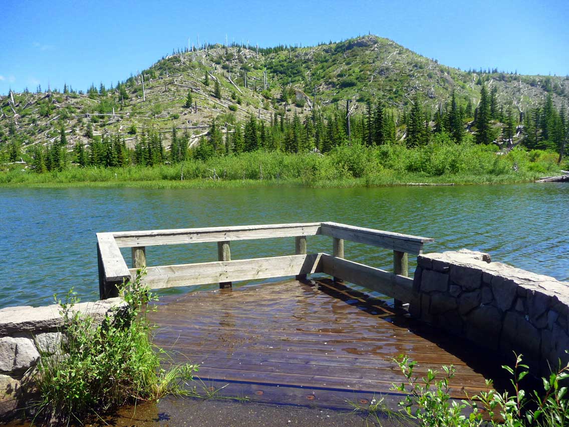
Stop 6: Miner’s Car & Meta Lake Viewpoint – Witness Mount St. Helens’ fury at this stop, still nine miles from the volcano. Coming to rest at this very place is a car that was hurled 60 feet into the air and then flattened during the eruption. The car’s owner and two family members tragically perished in a miner’s cabin nearby. Be sure to stroll or roll the easy, paved 0.25 mile trail to emerald Meta Lake. This interesting path leads through downed timber to a small mountain lake that was only moderately disturbed by the eruption. Look for the survivors — the small evergreen trees, fish, and frogs that lived through the blast buried beneath the snowpack. Search for signs of life that has since returned to the area after the eruption. After leaving the viewpoint, watch for views of Mount Adams, 28 miles to the east.
Stop 7: Cascade Peaks – Pull in at the new Cascade Peaks Interpretive Station. Cascade Peaks offers books, interpretive materials, snacks and drinks and visitor information. Recreation passes are available for purchase here. View status os Cascade Peaks here.
Stop 8: Independence Pass Trail – Now it’s time to strap on your walking shoes and enjoy the stunning volcanic landscapes and high country views along scenic Independence Pass. Just a short 0.25 mile hike and you’re rewarded with a striking view of Mount St. Helens, the crater, the lava dome and Spirit Lake. Witness the dramatic change in landscape that offers new insights into the ever-changing nature of our planet. Be amazed at the rapid return of life to this once gray and seemingly bleak land. The trail continues into the blast zone another 3.25 miles to a view of towering rock pinnacles revealed by the shattering force of the blast.
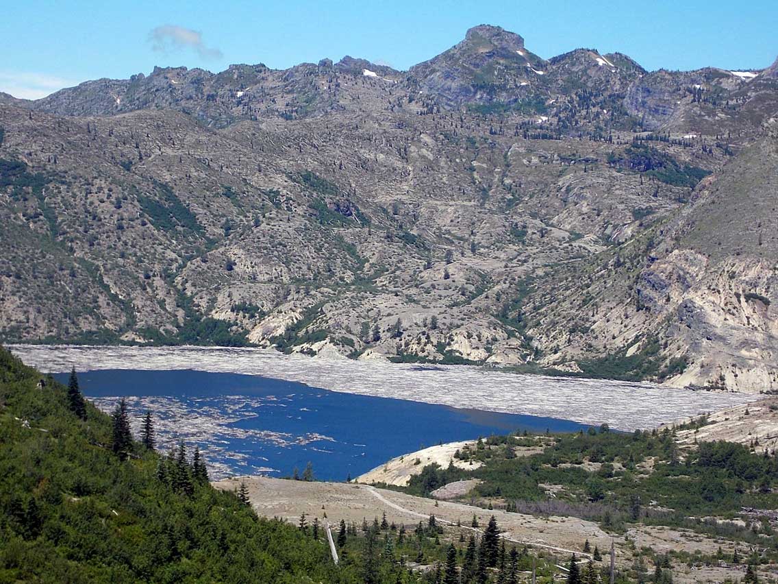
Stop 9: Harmony Basin Viewpoint & Trail – This is the place to look out upon famous Spirit Lake and Harmony Basin. A dramatic lake view, much of the surface of Spirit Lake is still covered by an ever changing matte of floating logs and debris from the blast. The day of the eruption, in nearly an instant, a massive landslide hundreds of feet thick sent waves 850 feet high across Spirit Lake, scouring its shores and pulling timber into its basin. Looking across the lake today see Harry’s Ridge and the popular Mount Margaret Backcountry. For a closer look, hike three miles round trip to the shores of Spirit Lake and see the effects of the 1980 eruption and marvel at the recovery. This is the only hike leading to its shores. Along this route, see what is left of Harmony Falls, a popular pre-eruption hiking destination. Once at the lake, view Mount St. Helens’ crater and the impressive, growing lava dome
Stop 10: Cedar Creek Viewpoint – Just a short drive down the road, look out onto the recovering Spirit Lake. Only one hike leads to the lake, and to the dismay of many anglers, fishing is not allowed. Strong populations of rainbow trout live in its waters today. A surprise to many as some thought this lake would never again support life. Choked with avalanche debris, the water temperature increased nearly 100 degrees Fahrenheit during the eruption when pyroclastic flows emptied into the lake. However, within five years after the blast, life had returned to the lake. The trees still float there today as a reminder of the mountain’s fury. Take time to read the interpretive sign at this astounding sight.
Stop 11: Donnybrook – Each stop offers a unique look at the dramatic landscape of the area. From Donnybrook Viewpoint, enjoy an impressive view of Spirit Lake with Mount St. Helens looming in the background. The trees that now drift in the lake were pulled into the lake off the surrounding hills by a huge wave triggered by the eruption. Enjoy the interpretive signs explaining the geology of this dramatically altered area.
Stop 12: Smith Creek Trailhead – If you have the time to hike even a part of nine-mile Smith Creek Trail, it is worth your while. A bit longer, but it showcases spectacular views of the blast zone. Descending steadily to Smith Creek, marvel at the immense impact the eruption of Mount St. Helens had on this creek as a giant mudflow poured through its banks during the eruption. Try to imagine the forest setting of this area before the eruption, over 25 years ago. The trail follows sections of old roads at times, so be sure to watch for the wooden post route markers. See the masses of logs carried by mudflows to their resting place along the river. Watch for the distant views of waterfalls as they plunge off rock cliffs. Notice the healing landscape and nature’s resilience.
Stop 13: Smith Creek Picnic Area – A great place for a quiet picnic lunch with friends, family and the mountain, this stop offers excellent close-in images of the volcano.
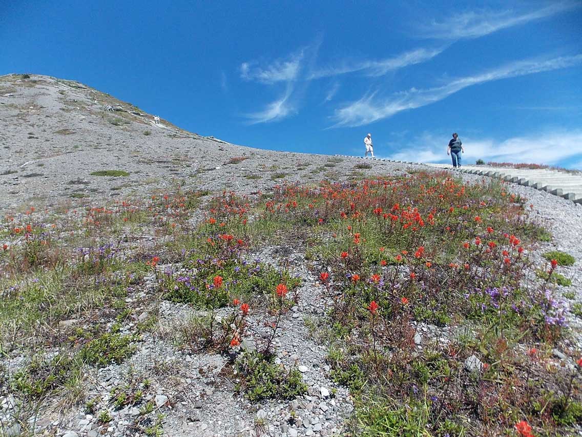
End: Windy Ridge – You’ve arrived at Windy Ridge. This is the top location along the route to view the devastation of the 1980 eruption. Nearly everything in view is within the area decimated by the eruption. Encounter the blast’s full impact as you transition from green forest to standing dead forest to blown down forest. Look out upon Spirit Lake’s immense floating forest. The landscape in this area is littered with sand and gray rocks from that event. For the best view possible, walk the 361 steps on the hill above the parking lot and feel as if you are looking directly into Mount St. Helen’s crater just five miles away. Take a moment to imagine the mountain’s fury the day of the blast. Around 90% of the missing mountain is laid out before you as part of the avalanche resulting from the eruption. View status of Windy Ridge Interpretive Site here.
All roads in this itinerary are winding and many have surface debris and steep drop-offs on either side. Always drive with caution, drive defensively, and expect wildlife. Motorcyclists should be especially careful. Please check local Ranger Stations for seasonal access dates and conditions. For current road conditions, click here.
![]()
Download the Windy Ridge Loop Road Trip Itinerary