Forever changing over 200 square miles of rich forestland into a gray, lifeless landscape, the 1980 eruption of Mt. St. Helens has had an impact so powerful, you have to see it to believe it. Over two decades later, witness the mountain’s slow but steady recovery. Journey through this healing landscape and behold nature’s awesome power.
Road Trip Itinerary
Length: 124 miles
Time to Allow: 4-6 hours
Open Season: Year-round. Spirit Lake Highway has limited winter access.
Driving Directions: Exit I-5 at Exit 68 and travel east on Highway 12 for 2.5 miles to Jackson Highway. From Highway 12 turn south on Jackson Highway and travel 6.9 miles to Highway 505. Turn left on Highway 505 and travel 13.8 miles to the Spirit Lake Memorial Highway 504. Turn left on Spirit Lake Memorial Highway 504 and travel 36.9 miles to the Johnston Ridge Visitor Center. Return via the same route along Highway 504 and Highway 505, 50.7 miles to Jackson Highway. Turn right on Jackson Highway and travel 1.2 miles to Spencer Rd. Turn right on Spencer Rd. and travel 10.6 miles to Fuller Rd. Turn left on Fuller Road and travel 1.1 miles to Highway 12 at Salkum.
Get the Scoop: Journey the Road to Mt. St. Helens with Hiking Expert, Karen Sykes. Read the story
Start: This journey begins at Exit 68 off I-5 on Highway 12.
Stop 1: John R. Jackson House – Just a few miles into the drive, check out the John R. Jackson House. This was the first American pioneer home built north of the Columbia River. Constructed in 1845 and rebuilt in the 1930s, it served as a stopover for travelers and in 1850 as a courthouse. It served as an instrumental location for the organization of the Washington Territory. The home houses original pioneer artifacts, on display, donated by the Jackson Family.
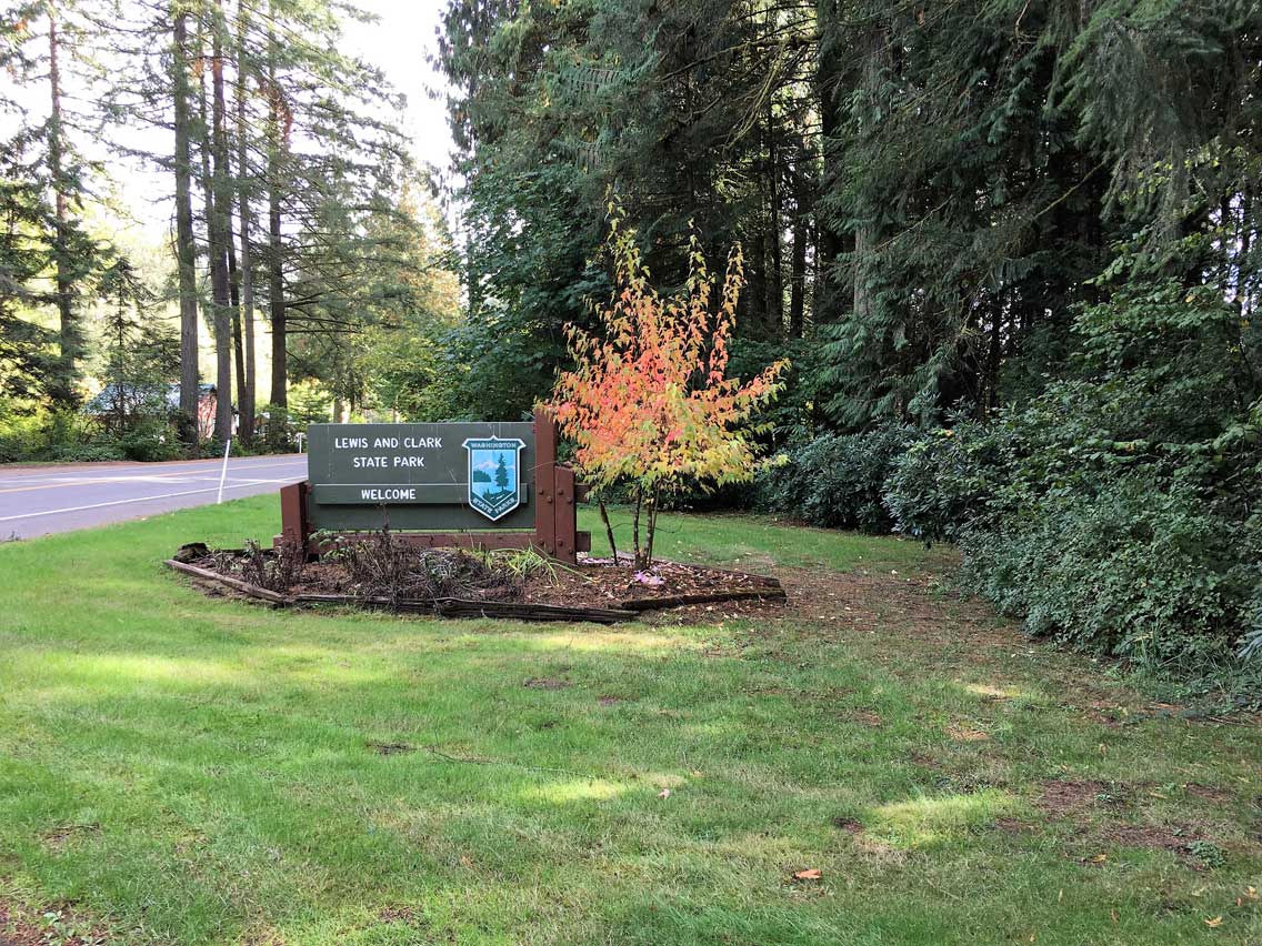
Stop 2: Lewis and Clark State Park – Less than a mile from the Jackson House, discover Lewis and Clark State Park. Located in a magnificent stand of old growth forest, this 621-acre park offers a beautiful outdoor environment with giant trees, bubbling streams, wetlands, and wet prairie land. Enjoy eight miles of hiking trails and five miles of horse trails, including the half-mile interpretive walk Trail of the Deer, featuring information on the park’s old growth forest. Children will enjoy the playfields and the playground. Every June, during Youth Fishing Month, children ages 14 and younger can fish the park’s creek.
Stop 3: Sediment Retention Structure Viewpoint – Stop for a look around this 5-acre day-use viewpoint offering a fascinating look at a dam designed for a different reason than most. Rather than water, this dam stops the downstream movement of sediment. Left unchecked this sediment loosened by the 1980 eruption, would clog the nearby Cowlitz River resulting in tragic flooding to the area. After viewing the interpretive information at the lookout, take a short one mile nature trail through young forests, over wetlands, past a meadow, eventually ending in a walk atop of the dam itself. Enjoy a breathtaking view over the dam’s edge and view the logs and debris far below. Be on the lookout for elk that frequent the area.
Stop 4: Weyerhaeuser Forest Learning Center – The Forest Learning Center formed in an alliance with Weyerhaeuser Company, Rocky Mountain Elk Foundation and the Washington State Department of Transportation celebrates the return of the forest to the Mount St. Helens area. Just months after the 1980 eruption, Weyerhaeuser hand-planted 18 million seedlings — trees today standing 70-feet tall. Learn about this forest recovery, reforestation and conservation of forest resources at the center. Hands-on and multi-media presentations allow visitors to take a stroll through a life-like forest and experience the Eruption Chamber. In addition to exhibits and displays, the center also features a playground, picnic area and an elk viewpoint.
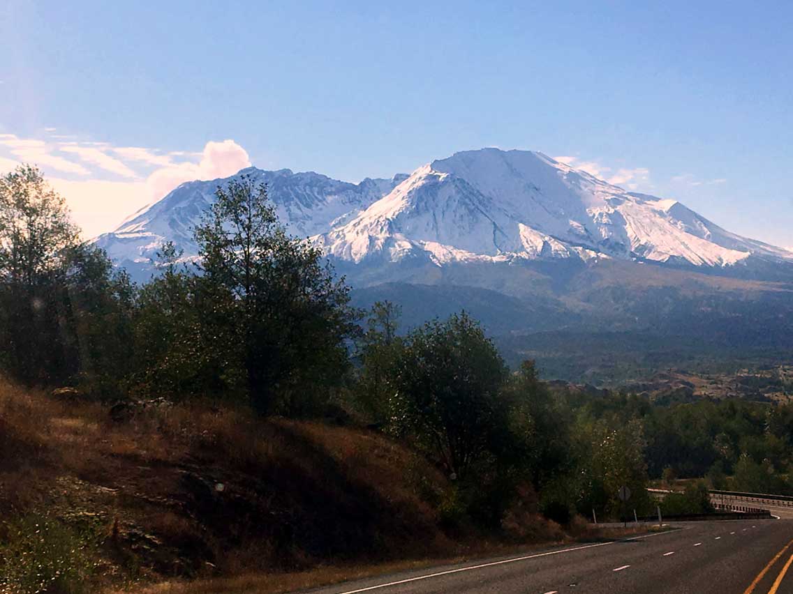
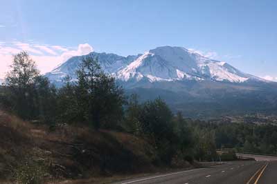
Stop 5: Elk Rock Viewpoint – Marking the boundary into the Mount St. Helens National Volcanic Monument, look onto hillsides where the fallen trees have not been harvested. Imagine the force of the blast knocking down 150 square miles of forest. Enjoy a fantastic view of the mountain. This is a popular area for Roosevelt elk; keep your eyes peeled for them grazing below.
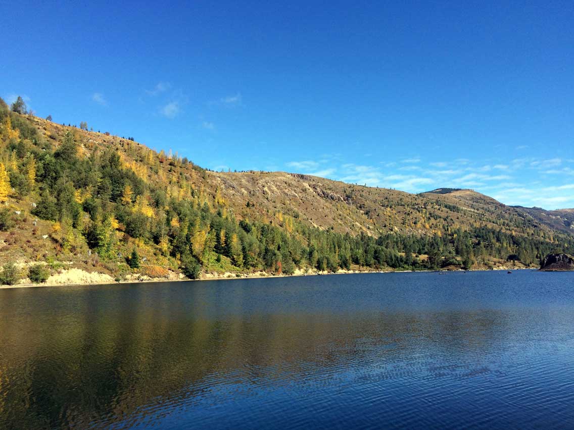
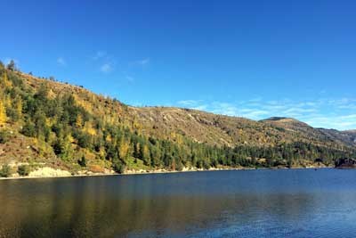
Stop 6: Coldwater Lake Recreation Area – Located in the heart of the blast zone, experience the eruption’s effect on the Coldwater Valley. See Coldwater Lake formed after the eruption when Coldwater Creek was blocked by the landslide. A healthy lake ecosystem has since developed naturally in the lake. Fishing is allowed and a boat ramp is available. Walk the short Birth of a Lake Interpretive Trail describing the events of the 1980 eruption that formed this lake. Enjoy spectacular lake views with Mt. St. Helens standing in the distance. Look and listen for the many birds that call this area home. Other facilities available include picnic tables, restrooms, a fish cleaning station, and a hands-on discovery area. The air is clean, the water so blue, the fish are big, the views are magnificent – stop, relax and reflect on the beauty and transformation of this area.
If you are visiting on weekends, the Coldwater Science and Learning Center is open to the public Saturdays and Sundays 10-4, from November to May. During this time, it is the closest access to Mount St. Helens from the west. A pet rest area is located within the Coldwater Lake area. There are two trails near the building perfect for exploration. Adjacent to the Science and Learning Center is the accessible Winds of Change Trail, a 1/4 mile paved path leading through a part of the Blast Zone.
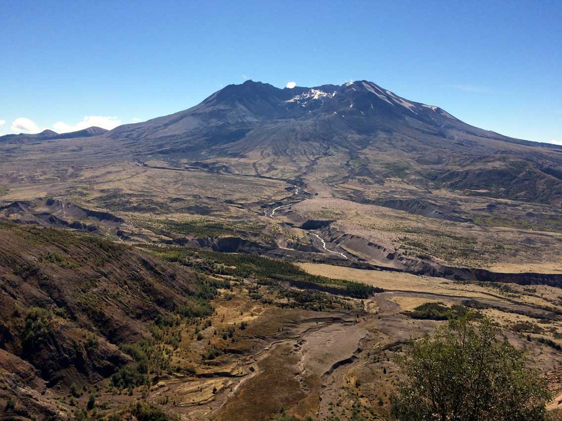
Stop 7: Johnston Ridge Observatory – Now just five miles from the crater, learn how the landscape was reshaped after Mount St. Helen’s 1980 eruption and discover how volcanoes are monitored today at the Johnston Ridge Observatory. The center’s state-of-the-art interpretive displays magically portray the sequence of geologic events that transformed the landscape and opened up a new era in the science of monitoring an active volcano and forecasting eruptions. Read amazing eyewitness accounts from eruption survivors. Take a 0.5 mile walk on the Eruption Trail and learn how the eruption shaped the surrounding landscape. Visitors can expect to see views of the lava dome, crater, pumice plain, and the landslide deposit. Forest Interpreters share the magic of the geological events surrounding the 1980 eruption through a variety of formal talks and guided walks. Book sales and limited food service are available.
Stop 8: St. Francis Xavier Mission – Stop and discover beautiful, historic St. Francis Xavier Mission sitting on the Cowlitz Prairie near Toledo on Spencer Rd. The first permanently established mission in the state of Washington, it was built in 1838. It is the site of the first settlers to the Lewis County area. Still in use today, see this historic church with views of Mount St. Helens. The church is adorned with beautiful stained glass windows, an arched entryway and an impressive steeple. One of the most interesting areas on the grounds is the historic Mount Calvary Cemetery, serving as the final resting place for some of the area’s original settlers.
Stop 9: Cowlitz Trout Hatchery – Drive another four and a half miles to the Cowlitz Trout Hatchery. This hatchery produces and releases over 1.5 million fish each year. This hatchery is the main contributor of steelhead trout to the Cowlitz River ranked as the state’s top steelhead river. Find public access to the river at the Blue Creek Boat Launch with ADA accessible fishing.
Stop 10: Cowlitz Salmon Hatchery – Continue six miles on Spencer Road, to the Cowlitz Salmon Hatchery to witness the fascinating process of fish raising and release. Once the largest salmon hatchery in the world, today it is still busy producing nearly 13 million salmon each year. Returning salmon are collected; their eggs harvested, and then kept in a series of pens until they are strong enough for release on their journey to the Pacific. View the Barrier Dam, located adjacent to the hatchery. The dam allows fish to pass, by diverting these migrating adults to a fish ladder.
End: This journey ends in the rural valley community of Salkum.
Always drive with caution, drive defensively, and expect wildlife. Motorcyclists should be especially careful. Please check local Ranger Stations for seasonal access dates and conditions.
![]()
Download the Mt. St. Helens Loop Road Trip Itinerary